Kumano Kodo - 熊野古道
■"Sacred Sites and Pilgrimage Routes in the Kii Mountain Range" -UNESCO World Heritage site-
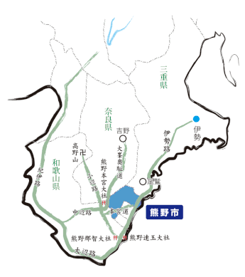
Kumano Kodo is a network of routes which stretches across the mountainous Kii Peninsula connecting sacred sites such as three Kumano grand shrines(熊野三山;本宮大社、那智大社、速玉大社), Koyasan(高野山), and Yoshino(吉野) from Ise grand shrine(伊勢神宮) and old imperial town.
Kii Mountain Range located roughly in the center of Japan has been considered a sacred site associated with nature worship since prehistoric times. Over 1,000 years, Buddhism and Shinto were uniquely mixted with nature worship in Kii Mountain Range and developed harmony between nature and human beings. Walking through Kumano Kodo to head to sacred sites, such as Kumano grand shrines, was a part of pilgrimage process. In July 2004, the “Sacred Sites and Pilgrimage Routes in the Kii Mountain Range” were registered as a UNESCO World Heritage Site (Cultural Heritage).
There are mainly five pilgrimage routes connecting each other; Nakahechi (imperial route from old imperial capital Kyoto to Kumano grand shrines,
which are Hongu(本宮大社), Nachi(那智大社), and Hayatama(速玉大社), via Osaka), Ohechi (coastal route from Tanabe(田辺) to Hayatama), Kohechi (mountainous route from
Hongu(本宮大社) to Koyasan(高野山)), Omine Okugake-michi (Shugendo, Japanese mountain asceticism route to Yoshino(吉野)) and Iseji (east coast route from Ise grand
shrine(伊勢神宮) to Kumano grand shrines(熊野三山)).
For more detailed information about each route, please refer to the following links.
-Nakahechi route, Ohechi route, Kohechi route, Omine Okugake-mich
■熊野古道是和歌山县南部通往三山的参詣道之总称。
沿纪伊山地走上遥远的参詣道,有各种各样的路线。参詣道也被称为熊野街道。
从京都途径难波(地名難波)沿海岸线至田边,再从田边沿山间至本宫的纪伊路,半道遥拜休息路是从田边沿山间继续行走至中边路分开。
围绕伊势有伊势路、十津川路、北山路、经过高野山的高野路,沿大峰山中修验道的峰入路等
作为朝圣道“纪伊山地的灵场和参拜道”于 2004年(平成16年)载入联合国教科文组织世界遗产(文化遗产)。
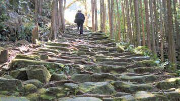
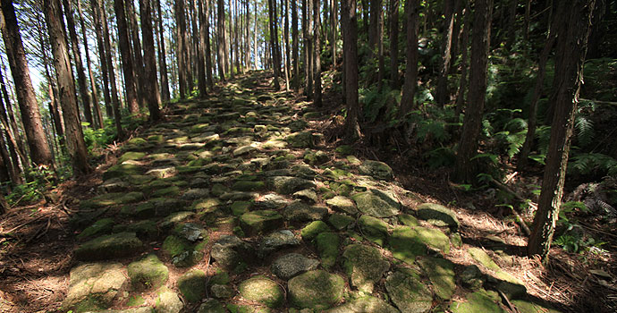
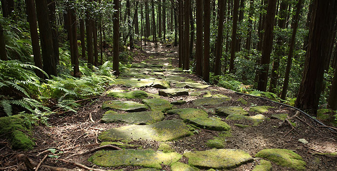
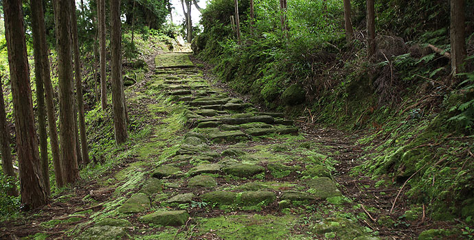
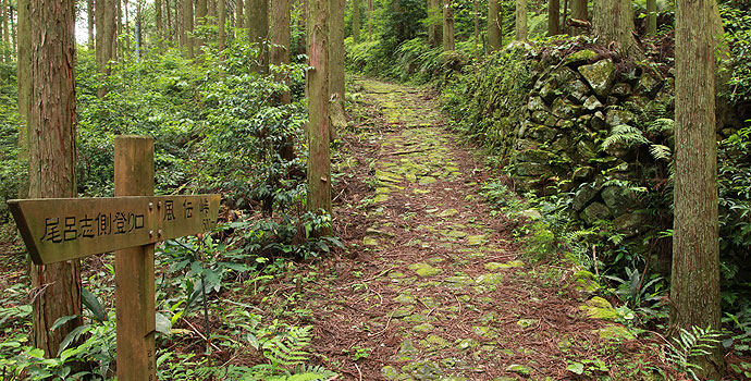
Toge(峠) on Iseji(伊勢路) route in Kumano city(熊野市)
Kumano city is located on Kumano Kodo Iseji route including following mountain paths.
Each path is a part of old pilgrimage route and also were the main streets, which were now replaced to R42, R311 and so on, only some decades ago.
It must be a special experience for the people to stroll even a part of Toge(峠) feeling breath of nature worship and people's living, listning to birds singing, deep green moss covering aciant stone path, and brilliant layer of sunshine coming through tall ceders.
“Sone-Jirozaka” and “Tarozaka”/曾根次郎坂、大朗坂
Hobo Mountain Pass, which forms the border between Owase City and Kumano City, is also known as “Sone-Jirozaka” and “Tarozaka.” A long time ago, it was this
mountain pass that established the boundary between the Kii and Shima provincial territories. The Kii-side of the mountain pass was known as “our territory” (jiryou) and the Shima-side of the
mountain pass was known as “their territory” (taryou). It’s from this, that the names “Sone-Jirozaka” and “Tarozaka” were formed.
The path from Sone (Owase City) to Nigishima (Kumano City) follows roughly the same course as the JR Soune Tunnel. The path continues straight ahead. If traveling
from Nigishima to Sone, the entrance for the trail is next to the tunnel.
In the olden days, there used to be a “houji-cha tea house” at Hobo Mountain Pass. Today, a trace of the tea house still remains.
■ Distance: Approximately 5km
■ Walking time: 2 hours 30 minutes (on average). Walking time may change depending on the person.
尾鹫和熊野的市交界处形成地甫母峠,也被称为曾根次郎坂、大朗坂。典故的由来,在很久以前,这里是纪伊和志摩的国界,究竟是自己的领土还是对方的领土一直不清楚。
从曽根到二木鸟的路线:和乘铁道JR曾根隧道路线基本相似,从峠到甫母的近路,沿街道直行,在隧道旁边有“从二木鸟登山入口出”的标志。 甫母峠很久以前有“焙茶茶馆”,现在也茶馆遗迹依然存在。
■距离:5km左右
■步行时间:2小时30分钟(普通情况。因人而异)
Nigishima Pass and Okamizaka Pass/二木岛峠(山岭)、逢神坂峠(山岭)
Connecting Nigishima and Atashika are the Nigishima and Okamizaka Mountain Passes. The JR Okamizaka Tunnel falls almost directly underneath the pilgrimage trail.
The trail follows a picturesque stone-paved path winding through a forest of cedar and cypress trees. With moderate ups and downs, visitors can enjoy a refreshing hike.
The name “Okami” comes from the meeting place of Ise and Kumano’s gods, and the theory that wolves used to frequently appear in this area too.
虽然熊野市的二木岛和新鹿相连,但二木岛峠(山岭)和逢神坂峠(山岭)的登山路线基本相同,都贯穿逢神坂隧道。山林宛如用柳杉和丝柏缝制的一般,整个山道由端正的石头铺成,台阶间合适的高对,使真个登山郊游过程都心旷神怡。“逢神”伊势的神仙和熊野的神仙相逢的地方,所以命名为逢神,后来也有传闻说,根据狼出没此地的典故而命名。
Hadasu Road/波田须的道
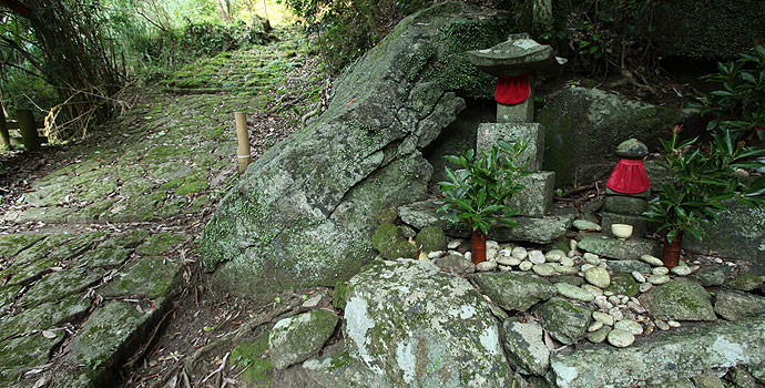
Hadasu is known as the village that Xu Fu, a court sorcerer from China, landed in during his search for immortality and the elixir of life. Just a short distance from the village, a large stone monument believed to be from the Kamakura Period rests along Hadasu Road. Also, since historic remains related to the legend of Kōbō-Daishi can be found here, Mie Prefecture designated this road as the “Mothers and Children’s Nature and History Trail.”
传说,中国徐福东寻不老不死仙药,登陆于波田须,离这不远的地方,有意想不到的镰仓时代的大巨石,同时这里也有关于弘法大师传说的遗迹,属于三重县指定的“自然历史母子散步道”。
Obuki Mountain Pass/大吹峠(山岭)
While the majority of the Kumano Kodo travels travels through cyprus and cedar forests, the Obuki Mountain Pass trail used to be surrounded by a bamboo grove.
Currently, due to thinning of the forest, the impression its bamboo makes is not as strong as it used to be.
Up until around 1950, there used to be a tea house on the mountain pass. At its peak, this stone-paved mountain pass was a cornerstone for traffic in the
area.
大吹峠通往山顶的路两旁,种有一半以上的丝柏和柳杉,这景象在整个熊野古道中也是罕见的,充满大吹峠特殊风情的大竹林,因最近采伐山林,找不到以前,那种穿梭于山林的感觉了。
据说昭和25年左右(1950年)在这个峠(山口)有一间大吹茶屋,后因此地属于交通要道而关闭,所以现在成了只剩下石台的峠道。
Kannon Road/观音路(观音)
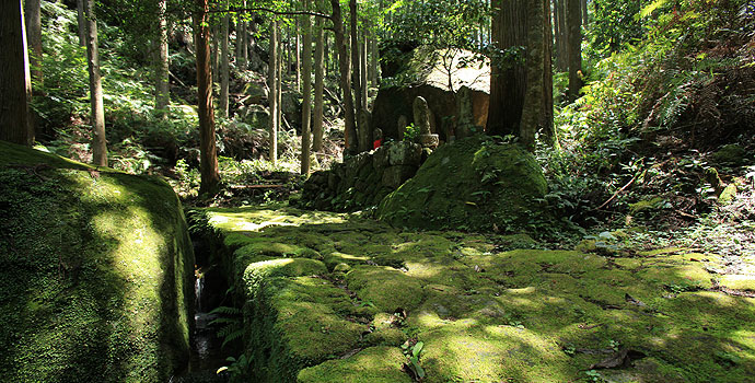
This is a religious path connecting Odomari and Hadasu. Approximately 1 kilometer into the mountain trail and you will find Hionzan-Seisuiji Temple Ruins (commonly
called Tomari Kannon).
The path leading up to the temple is steep, but there are Buddhist statues lining the slope to comfort passerby pilgrims. When the Kannon Faith was spreading to all
of Japan during the Edo Period, the neighboring villages around Tomari Kannon started the Kannon Religious Association. Additionally, many believers donated Buddhist statues connected to the
Saigoku Kannon Pilgrimage. The statues scattered along the path are reminiscent of the prosperous times long ago.
According to legend, Seisuiji Temple was built by General Sakanoue no Tamuramaro during the Daidou era (year 809) to chase out Ogres from the area.
Kannon Road is a beautiful cobbled-stone path lined by many Buddhist statues.
从大波到波田的信仰路。距离山道一千米左右的地方有比音山清水寺遗址(通称泊观音)。在陡坡处参道旁边有慈悲的石佛。在全国信仰观音盛事的江户时代,泊观音的附近也有信徒聚会传教,通往西国三十三所(日本有名的33个寺院)的途中留下了众多信徒布施的佛像,看到此景,情不自禁的联想起当时的繁荣景象。清水寺:建于大同4年(809年),建筑师:坂上田村麻吕
相传这里是击退魔鬼的地方。
观音道的路边留下了无数的石佛,道路也是由美丽石头铺成的。
Matsumoto Pass (Matsumototoge)/松本峠(山岭)
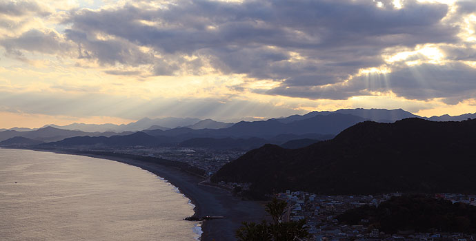
From the arbor in Matsumoto Pass, the Shichirimihama Beach Trail can be seen. (Shichirimihama Coast)
Connecting Kumano City’s Odomari and Kinomoto towns, Matsumoto Pass is scenically located near the mountains next to Onigajo. It’s elevation reaches approximately
120 meters above sea level and can be climbed in about 30 minutes.
With the stone-paved trail covered in moss, hikers can truly appreciate the age and atmosphere of the pilgrimage road. Jizo, a guardian deity supposedly shot with a
gun, stands on the path surrounded by bamboo. Additionally, halfway through the trail, the endlessly sweeping curve of Shichirimihama Beach can be seen from the arbor. It is said that this is the
greatest view of the Kumano Kodo Pilgrimage Trails. If you walk this trail with your own feet, it will leave you feeling refreshed. We truly encourage you to experience this for yourself. After
gently descending from this point, the trail gradually continues into the beach-side trail.
松本峠(山岭)从东屋(地名)一览滨街道
将熊野市的大波和木本连接到一起的峠(山岭),位于名胜、鬼城的山手处,海拔20米左右,徒步到山顶需要30分左右,古道的石台阶布满了青苔,这里充满了最原始地古道山林气息。传说在被竹林环绕的山路中,一位被枪击中的地藏(菩萨)站在半山腰的东屋,一览,由柔和曲线式的小道延伸到七里御滨的美景。这里是熊野古道观景的最佳视角。您也来体验一下徒步古道的爽快心情吧!沿着不陡的下山的古道可以继续体验滨街道。
Fuden Mountain Pass (Fudentoge)/风传峠(山岭)
Fuden Mountain Pass is located on the border of Mihama Town and Kumano City.
The name “Fuden” originally comes from the frequent winds blowing through the area. Additionally, Oroshi Village, located at the foot of the pass, gets its name
from the wind blowing down the mountains.
If you take Hongu Road from Arima, this trail eventually diverges into into the Kitayama Trail bound for Yoshino.
The Fuden Mountain Pass was important for connecting the coast of Kumano and the mountain villages until the Fuden Tunnel of Route 311 was built. Even though the
pilgrimage road was split by the former national highway, the trail still leads to the mountain pass and Kiwa-Cho (Kumano City).
位于熊野市和御滨镇的境内
風伝峠是,有马通往本宫道方面,以及通往吉野方面的北山道的三岔路口,也是连接熊野海边和山村的要地。“风传”是“风颠”的借用字,这里“风”表达的是通风的场所,据说这里的风是从下脚下的尾吕山口处吹过来的。这条山路是贯穿位于国道311的风传隧道到海边和山村的重要路线。这条山路也是越过旧国道直通熊野市纪和镇的路
Tori Toge Pass and Maruyama Senmaida/通峠和丸山千枚田
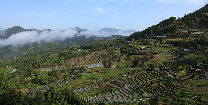
From the base of Fuden Toge(hill) Pass, Hongu Road splits into Kitayama Road, heading north towards Yoshino (Nara Prefecture) and the path leading to Tori Toge(hill) Pass. On the mountain pass, approximately 1 kilometer into the trail, the guardian Koyasujizo is enshrined in stone surrounded by ferns. Additionally, there is an observation deck on the east-side of the trail, partially hidden by the forest. From the observation deck, a superb view of Maruyama Senmaida, one of the best sights in Japan, is visible. Maruyama Senmaida has been selected as one of “Japan’s Top 100 Terraced Rice-Fields.”
在“风传山”脚下,有一条分岔路,将去本宫道和北上吉野的北山道分开。这是一条供奉着子安地藏,石阶长有厥类植物,长约一千米的古道。虽然山林密不透风,但在山顶设有展望台,从展望台可以眺望,日本梯田百选之一的“丸山千枚田”的全貌。
Coastal Road (Hamakaidou)/滨街道
Shichirimihama has been chosen as one of the "100 Best Japanese Beaches". Extending over 25km, it has been designated as part of the Kumano Yoshino National Park. Shichirimihama Road breaks off from the main shrine road towards the west near Hana no Iwaya Shrine, which is said to be the tomb of Izanami no Mikoto. The object of worship at Hana no Iwaya is a large rock with a height of about 45m.
日本海滨百选之一的七里御滨是一条从熊野市到熊野川的滨街道,一直延长到25公里,国家指定的熊野吉野国立公园。
七里御滨街道也被称做为巡礼道,从伊奘冉尊的御陵—花窟往西不远处就是去本宫道的路。「花窟」是高约45米的巨岩石,传说是御神体。